Farrar Road

classic Classic list List threaded Threaded
14 messages Options
Glynne Glynne
Reply | Threaded
Open this post in threaded view
|

Farrar Road

Does anyone know who the "Farrar" was in "Farrar Road"?
David Price David Price
Reply | Threaded
Open this post in threaded view
|

Re: Farrar Road

Farrar Road was developed on land owned by W. Farrar Roberts in 1893.  He lived at Llwyn Eithin (now Hillgrove School), Ffriddoedd Road. He was a member of the city council, and I seem to think he was an accountant, but I'm not sure.

You have probably read John Cowell's excellent History of Bangor Cricket Club in which he explains how the football clubs had to move from Maes y Dref in the early 1920s and play on the cricket ground at Farrar Road (Penrhyn Estate land). In 1928, the Cricket Club moved to Ty Newydd.
Glynnr Glynnr
Reply | Threaded
Open this post in threaded view
|

Re: Farrar Road

In 1920, Bangor Comrades played football against the Bangor Railway Institute. The newspaper report stated that the Railway Institute had "secured its old ground at Ffriddoedd Road opposite Friars School."
I'm presuming that this is not the old Friars playing fields, but land where Maes Tryfan or Coleg Menai have been built, as this would have been near the Railway Institute.

Does anyone know anything about where this playing field may have been?
David Price David Price
Reply | Threaded
Open this post in threaded view
|

Re: Farrar Road

There was very little development along Ffriddoedd Road west of Llwyn Eithin (Hillgrove School) until the 1930s.  The 1913 OS map shows that Friars School was surrounded on all sides by green fields and directly opposite the school were two large fields. To the south-east was a field on which Caernarvonshire Technical College (Coleg Menai) was built in the late 1950s.  To the south-west was  a field on which Maes Tryfan Estate was built (first house occupied 1935).

A field at the western end of Ffriddoedd Road at its junction with Belmont Road became the playing field of the newly built Bangor County School for Girls (Ysgol Tryfan) in 1939, but the 1913 map shows tennis courts on a small portion of the field. These were probably for the University College.  There was another tennis court shown adjacent to Eithinog farm.

Could it be that soccer was played near the tennis courts, or is it more likely that the railwamen played in the field directly opposite Friars School which is a little nearer the Railway Institute?
Admin (Matt) Admin (Matt)
Reply | Threaded
Open this post in threaded view
|

Re: Farrar Road

This post was updated on .
In reply to this post by Glynne


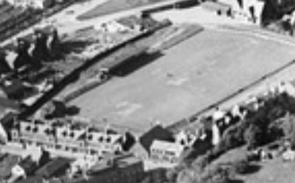
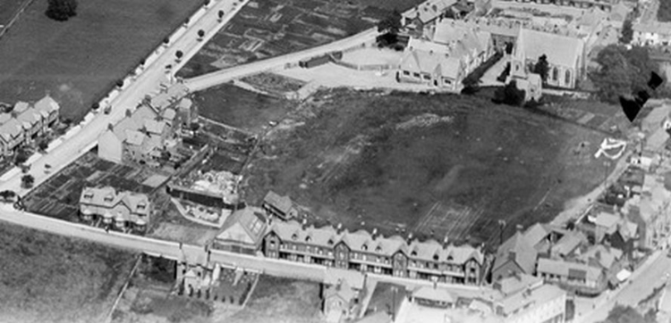
Early aerial view of Farrar Road - In the latter cricket days by the looks of it, pre-1930s due to lack of buildings such as the Masonic Hall


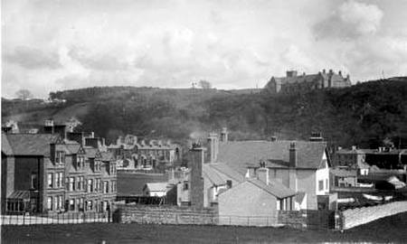
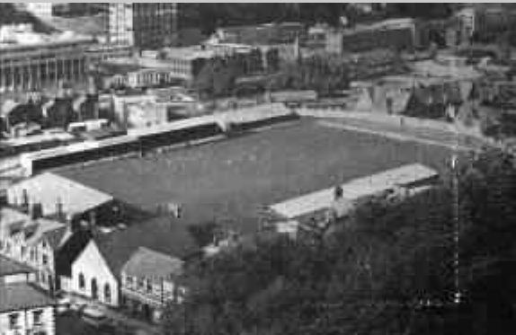
From the top of Farrar Road


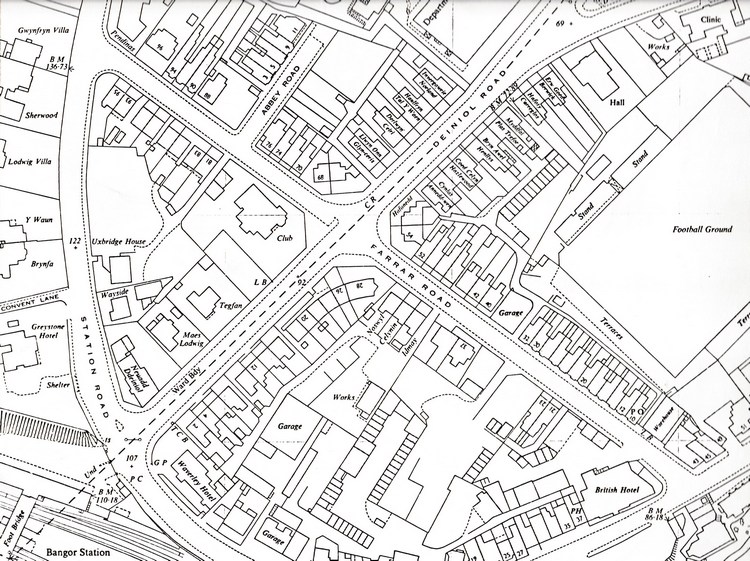
From Council archives...
195. 1844-1868 FILE of Certificates of Births, Marriages and
Deaths re Rev. William Williams, Rector of
Llanddyfnan, and his dau. Elizabeth Morris
Roberts, prepared in respect of documieits of
title of W. Farrar Roberts, esq. to
Caemaeslodwig estate, Bangor.

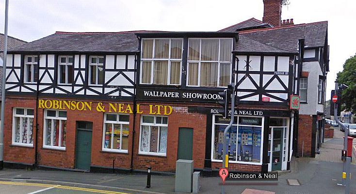
the golf club also have some sort of "Farrar Roberts Cup Medal" (still going..)
Dave Dave
Reply | Threaded
Open this post in threaded view
|

Re: Farrar Road

I quite like the small trees along Deiniol Road.
matt2 matt2
Reply | Threaded
Open this post in threaded view
|

Re: Farrar Road

No doubt they made a right mess of the pavement though

I've always liked 43 high street, with the old farrar road street sign on...

Glynne Glynne
Reply | Threaded
Open this post in threaded view
|

Re: Farrar Road

In reply to this post by Admin (Matt)
Thanks for the photo. Excellent.
Is it OK to use it in the book?
Glynne Glynne
Reply | Threaded
Open this post in threaded view
|

Re: Farrar Road

In reply to this post by Dave
Looking again at the earlier photo - the first Deiniol Road stand at the football ground was built in the early 1920s, so this photo possibly pre-dates the football club's move to Farrar Road.
Admin (Matt) Admin (Matt)
Reply | Threaded
Open this post in threaded view
|

Re: Farrar Road

We know Deiniol Road opened in 1904, wider images show no memorial arch so it's pre 1923.


Above from a later image seems to be the first football stand.
Glynne Glynne
Reply | Threaded
Open this post in threaded view
|

Re: Farrar Road

In 1921/22, a “grandstand” was erected at Farrar Road (the one shown), at a cost of £500 from the proceeds of the first season. In 1923, dressing rooms were moved to Farrar Road from the old Railway Institute. Neighbouring Caernarfon Athletic had been striving to match their Bangor counterparts, but by the 1920s, the Caernarfon chairman, J. B Parker, decided that he could no longer finance the club, and sold the grandstand that had been erected at Caernarfon to Bangor in exchange for £80-worth of shares in the Bangor club. Unfortunately for him, Bangor Athletic Football Club was wound up shortly afterwards, making the shares worthless.  The grandstand, however, was inherited by Athletic’s successor organisation, Bangor City, and was a permanent fixture at Farrar Road until it faced the bulldozers in 2012
Admin (Matt) Admin (Matt)
Reply | Threaded
Open this post in threaded view
|

Re: Farrar Road

Glynne,

That's really interesting, I had no idea.

Some more old pics of the same stand...


Glynne Glynne
Reply | Threaded
Open this post in threaded view
|

Re: Farrar Road


"Farewell Farrar Road: 50 key events that shaped the history of Bangor City" is now for sale.  Priced £20, or £25 for a signed copy, this 220-page full-colour book details the history of the football club through the main events that occurred at Farrar Road.

All proceeds from the book will go towards building a new terrace at the Nantporth Stadium.

Copies are available from the club at Nantporth, or through the Bangor City Facebook pages. Copies will also be for sale over the next 2 weekends in the City Centre, where the Supporters will have a stall selling club merchandise.
Admin (Matt) Admin (Matt)
Reply | Threaded
Open this post in threaded view
|

Re: Farrar Road

This post was updated on .
In reply to this post by Glynne
(p332) from the thesis. "Plans were drawn up by the City Council for a road 48 feet wide to run from Garth Road to join the Holyhead Road near the railway station. An agreement was reached with Lord Penrhyn in 1894 and with Mr Farrar Roberts in 1898 to run the road across their land. When the Council purchased the bishops estate the way was finally clear for the construction of this road, called Deiniol Road. By 1914 several short terraces had been built fronting onto the road. A little earlier, in the 1890's Mr Farrar Roberts, who had acquired the land from the Maeslodwig Estate which lay east of Holyhead Road, constructed a road, Farrar Road, across this property to develop it for building purposes. Short Terraces were built on the eastern side of this road, and on Abbey Road a cul-de-sac. Completion of the development in this area had to wait until the 1930's ". (there are references to the 1894/1898 dates - B.C.C.M 7 Feb 1894 and 5th Jan 1898 - which I guess may be Bangor City Council Minutes?)

Farrar Roberts was born in 1868 and married Jane Hunt in Manchester 14th Sept 1892 and had two daughters Elsie and Yolande. He appears to have moved to Bournemouth later on, and on 14th October 1925 he and Jane are on the passenger manifest for the "Koningin Der Nederlanden" destination port Genoa, Italy. He was 58 at the time.

That said he appears to return back to the Poole/Bournemouth area where he died aged 75ish on 3rd Feb 1938 (see attached) The London Gazette Publication date:5 April 1938 Issue:34499 Page:2299

Full map image: Farrar_Road.jpg