Bangor Civic Society | Message Board & Forum
› General
›
City, Buildings, Businesses and Land History
Bangor Castle


|
|
This post was updated on .
Ordnance Survey 1905
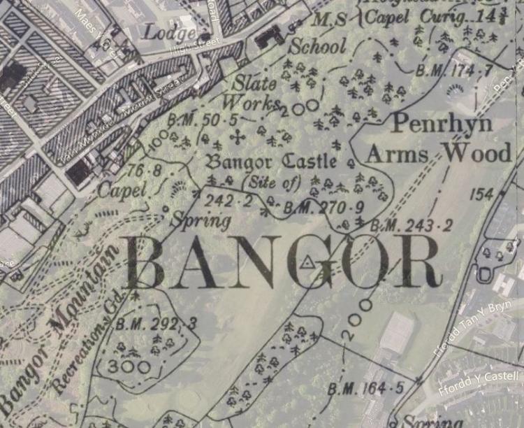 North Wales Chronicle - Saturday 13 September 1884 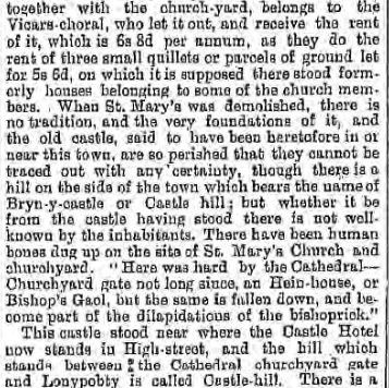 Archaeologia Cambrensis - Third Series No. XLVI April 1866, p117  GAT Castle, Possible Site of, Bangor Primary Reference Number (PRN) : 2301 Trust : Gwynedd Community : Bangor NGR : SH58597224 Site Type (preferred type first) : Medieval CASTLE Legal Protection : Description : A castle east of Bangor, shown to Pennant by Hugh Lupus. Three sides of the walls easily traced, the fourth side had a strong natural defence. The site is described as 'entirely imaginary' by W. J. Hemp. The site is a complex series of ridges created by outcrop rock but there are no traces of a castle. Professor Glyn Roberts had no knowledge of a castle having existed at this site and stated that the only evidence for the site was that given by Pennant. <1> It is recorded in the near contemporary biography of Gruffudd ap Cynan that a castle was built at Bangor by Earl Hugh of Chester. This would have been a motte, built during one of Earl Hugh's raids between 1081 and 1093. The location of the castle is not known, but two sites are generally suggested - one on Bangor mountain, where Pennant, in the late 18th century, was told it was sited, and the other on Roman Camp (PRN 2299) on the opposite Aethwy ridge. (Berks & Davidson, 2007) ************ Also known as, or recorded in historical documents as; Bangor Castell OS Map Grid Reference: SH58327127 Latitude 53.21955° Longitude -4.12348° Bangor Castle has been described as a Timber Castle although is doubtful that it was such. There are no visible remains. Description About the year 1080, Hugh Lupus, Earl of Chester, in order to assist his descent upon the Isle of Anglesey, and to secure the conquests he had already made in North Wales, erected a castle, about a quarter of a mile south-east of the city, on the ridge of hills which bounds the vale. Of this castle, no particular event is recorded in the history of the principality; probably after the restoration of Grufydd ab Cynan to the throne from which the earl had expelled him, it was either destroyed immediately, or suffered to fall gradually into ruins. (Lewis 1849) The Tithe Award map is marked Castell at this spot, RCAHMW fieldwork in 1948 describes the site as comprising a semi-circular rampart with no structural remains. RCAHMW Investigator, W.E. Griffiths suggests the site is unlikely to be ancient and believes that the mound may be the remains of quarrying or may possibly be connected with the construction of the adjacent railway tunnel. Source: NMR site files. (Coflein) Comments The castle built by Hugh is usually supposed to be Aber. This can not be railway spoil if seen by Lewis before 1849, well before the construction of the railway. The Tithe map is also likely to have been made well before the existence of the railway so even if Griffiths was not aware of Lewis his dismissal of the site as 'unlikely to be ancient' seems injudicious. The location is most like that of a barrow. It would seem to be a damaged mound and the semi-circular form may suggest a barrow that has robbed. ///////////////////// The early Norman castles of the British Isles by Armitage, Ella S Published 1912  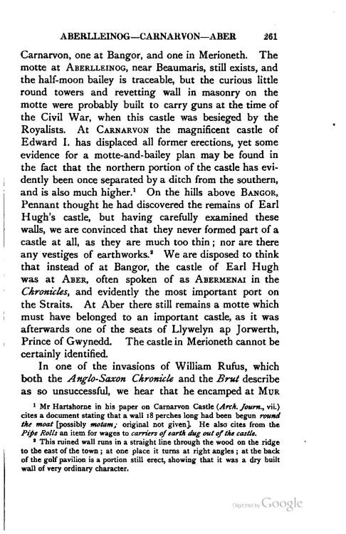 ////////////////////////////// A Topographical Dictionary of Wales. Originally published by S Lewis, London, 1849. In 1071, the city suffered material injury, and the cathedral was destroyed by an English army that invaded this part of the principality. About the year 1080, Hugh Lupus, Earl of Chester, in order to assist his descent upon the Isle of Anglesey, and to secure the conquests he had already made in North Wales, erected a castle, about a quarter of a mile south-east of the city, on the ridge of hills which bounds the vale. Of this castle, no particular event is recorded in the history of the principality; probably after the restoration of Grufydd ab Cynan to the throne from which the earl had expelled him, it was either destroyed immediately, or suffered to fall gradually into ruins. The city recovered from its devastation, but the cathedral remained in a ruinous state till 1102, when a synod was held at Westminster, for the reformation of the Church //////////////  
|
|
|
This post was updated on .
 With reference to the castle that Hugh Lupus, Earl of Chester, is said to have erected on a high rock overlooking the town, it is thought that it was little more than a look-out post or small wooden fort, and the site is thought to be high above the present parking ground belonging to KWIKS store et the bottom of the town. I recall going up there to investigate when I was about 15 years of age, and there are certainly traces of earthworks or foundations. Another pointer is the number of houses and streets with the word Castle which exist today: Castle Hotel, Castle IIi[ Castle Street, Castle Bank, Castle Terrace [Bron Castell] etc. The Welsh ru]me for this little fort is said to have been Castell Bryn Eryr [?1. There is an old tradition that a long time ago part of the walls of the old castle fell into a pool situated where the Kwiks parking grorurd is. It is also said that a stream from this pool joined the river Adda from the notes of Mr Idoles Owen 1907-1998 |
«
Return to City, Buildings, Businesses and Land History
|
1 view|%1 views
| Free forum by Nabble | Edit this page |